An example info-graphic from the WI DPI Youth Risk Behavior Survey

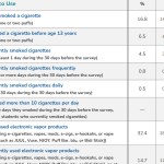
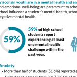
DPI WI Youth Risk Behavior Survey

The Wisconsin Youth Risk Behavior Survey (YRBS) has been conducted every two years since 1993. The health-risk behaviors monitored include mental health, traffic safety, weapons and violence, suicide, tobacco use, alcohol and other drug use, sexual behavior, nutrition, and exercise.

Read More...
Map of Native language groups in WI from NativeLandDigital

Native Land Digital

Native Land Digital is an evolving and Indigenous-led educational tool designed to support Indigenous self-determination, visibility, and connection.

Read More...
Equitable Program Development Dashboard

Equitable Program Development Dashboard

The EPD maps five categories of socioeconomic and demographic Census data at the County, County Subdivision, Tract, and Block Group levels, and includes a number of community assets for additional local context.

Read More...
Screenshot of typical output from the Disability Statistics website.

Disability Statistics

Disability Statistics is a state-level database designed to provide policy makers, advocates, journalists, and the public with access to demographic and socio-economic statistics on the non-institutionalized population of the U.S. with disabilities.

Read More...
An example of a map generated by StatsAmerica

StatsAmerica

StatsAmerica is an extensive and up-to-date collection of data and indices related to economic and community development. The site is also a handy source of Census and other federal data at the County, Place, or MSA level.

Read More...
Screenshot of PolicyMap with example data for Counties in Wisconsin.

PolicyMap

PolicyMap makes one of the most extensive lists of demographic and socio-economic variables accessible in one place—at nearly every level of geography imaginable. Current Census data exists alongside historical data of various types.

Read More...
Screenshot of a U.S. Census QuickFacts table.

US Census QuickFacts

The U.S. Census’ QuickFacts site provides a customizable table of common demographic and socio-economic statistics for the U.S., individual States and Counties, or cities and towns with populations of more than 5,000 people.

Read More...
Screenshot of typical data from the EPA's EJScreen database mapped for Wisconsin,

EPA’s EJScreen

EJScreen, the EPA’s Environmental Justice Screening and Mapping Tool is designed to highlight places that may have more exposure to health-impacting environmental risks and under-resourced or more vulnerable populations.

Read More...
WI DHS logo

DHS Open Data Portal and WISH

The DHS Open Data Portal provides an extensive list of data related to health and behavior including: birth and death rates, life expectancy, illness, insurance, public health, lead, mental health, and substance use.

Read More...