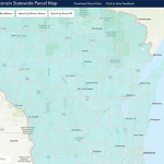
Statewide Parcel Map Initiative
This resource aggregates local parcel datasets into a statewide file. The data includes typical attributes such as owner name, address, school district, assessed values, and property tax.
Read More...
This resource aggregates local parcel datasets into a statewide file. The data includes typical attributes such as owner name, address, school district, assessed values, and property tax.
Read More...
The USDA conducts a census of U.S. farms and ranches at five year intervals looking at “land use and ownership, operator characteristics, production practices, income, and expenditures.”
Read More...
The DHS Open Data Portal provides an extensive list of data related to health and behavior including: birth and death rates, life expectancy, illness, insurance, public health, lead, mental health, and substance use.
Read More...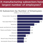
County Business Patterns, from the U.S. Census, provides economic data by industry and number of employees. The County-level data includes the number of establishments by NAICS code, number of employees by sector, and annual payroll by sector.
Read More...
The United Way developed the ALICE (Asset Limited, Income Constrained, Employed) metric to examine the group of households earning more than the Federal Poverty Level, but not enough to afford the essentials for survival in the communities in which they reside.
Read More...