Consistency with the Comprehensive Plan
Wisconsin’s Comprehensive Planning Law requires land use regulations to be consistent with an adopted comprehensive plan. More precisely, the law states “beginning on January 1, 2010, if a local governmental unit enacts or amends any of the following ordinances, the ordinance shall be consistent with that local governmental unit’s comprehensive plan.” Ordinances that must be consistent include:
- Official mapping ordinances established or amended under Wis. Stat. § 62.23(6).
- Local subdivision ordinances enacted or amended under Wis. Stat. §§ 236.45 or 236.46.
- County zoning ordinances enacted or amended under Wis. Stat. § 59.69.
- City or village zoning ordinances enacted or amended under Wis. Stat. § 62.23(7).
- Town zoning ordinances enacted or amended under Wis. Stat. §§ 60.61 or 60.62.
- Shoreland or wetland zoning ordinances enacted or amended under Wis. Stat. §§ 59.692, 61.351 or 62.231.
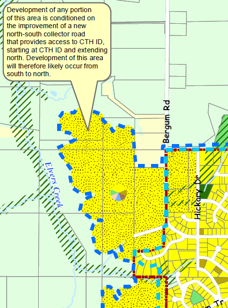
Consistent means “furthers or does not contradict the objectives, goals, and policies contained in the comprehensive plan.”1 Although the law does not require it, good planning practice suggests that other land use ordinances and actions should also be consistent with the comprehensive plan and other locally adopted plans. When inconsistencies exist or are proposed, the local government has three options. It may: 1) modify or deny the proposed change, 2) amend the ordinance, or 3) update the comprehensive plan to make it consistent with the ordinance. If a zoning, subdivision or official mapping ordinance adopted or amended after January 1, 2010 is not consistent with the comprehensive plan, the ordinance may be subject to a legal challenge. The map to the right and the Consistency Matrix Table located in Resources below illustrate how a comprehensive plan can be used to guide future development in light of the consistency requirement. The map shows how the text of the comprehensive plan can be used to explain timing and phasing issues not readily depicted on the future land use map. The table identifies zoning districts that are consistent with the future land use categories recommended in the comprehensive plan. Graphic from Village of Mt. Horeb Comprehensive Plan, 2009, Map 4b: Future Land Use. www.mounthorebwi.info