A General History of Upham Woods
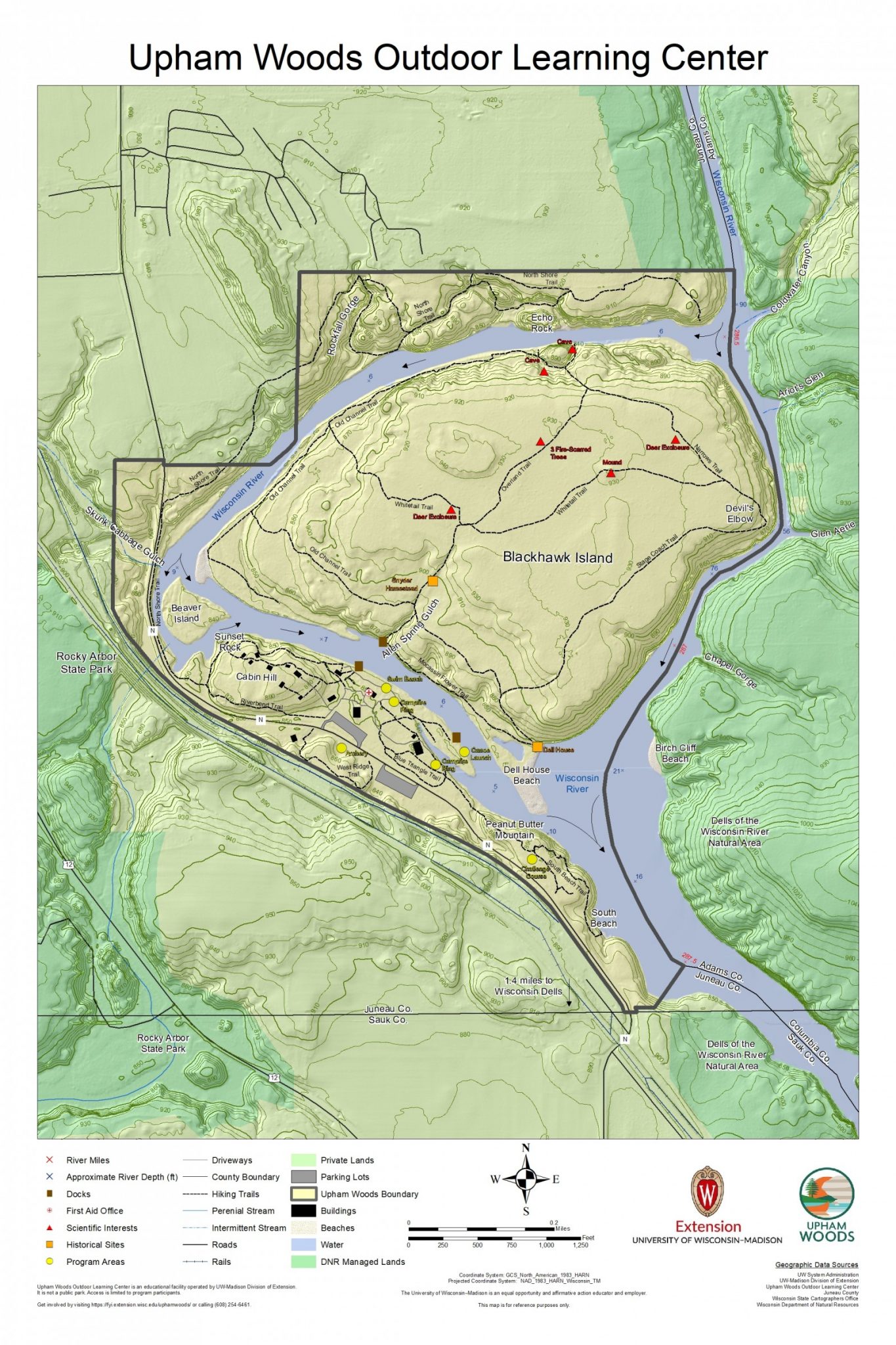
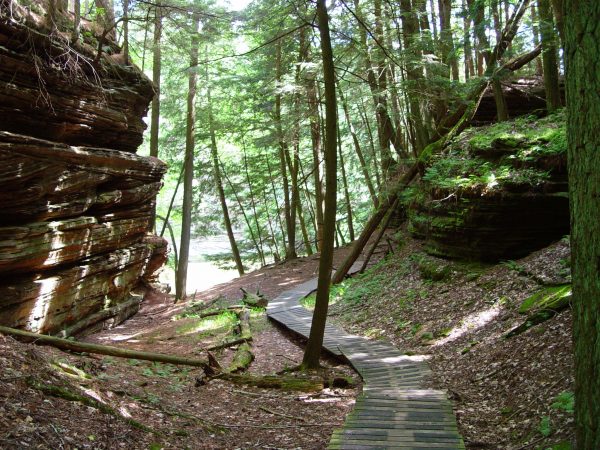
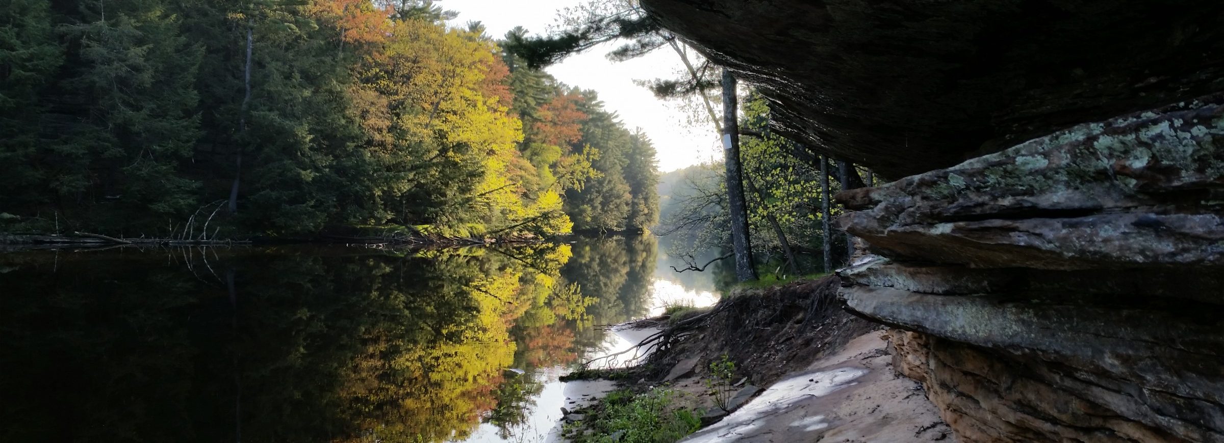
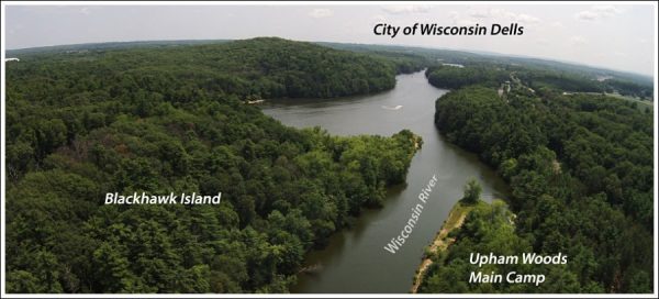
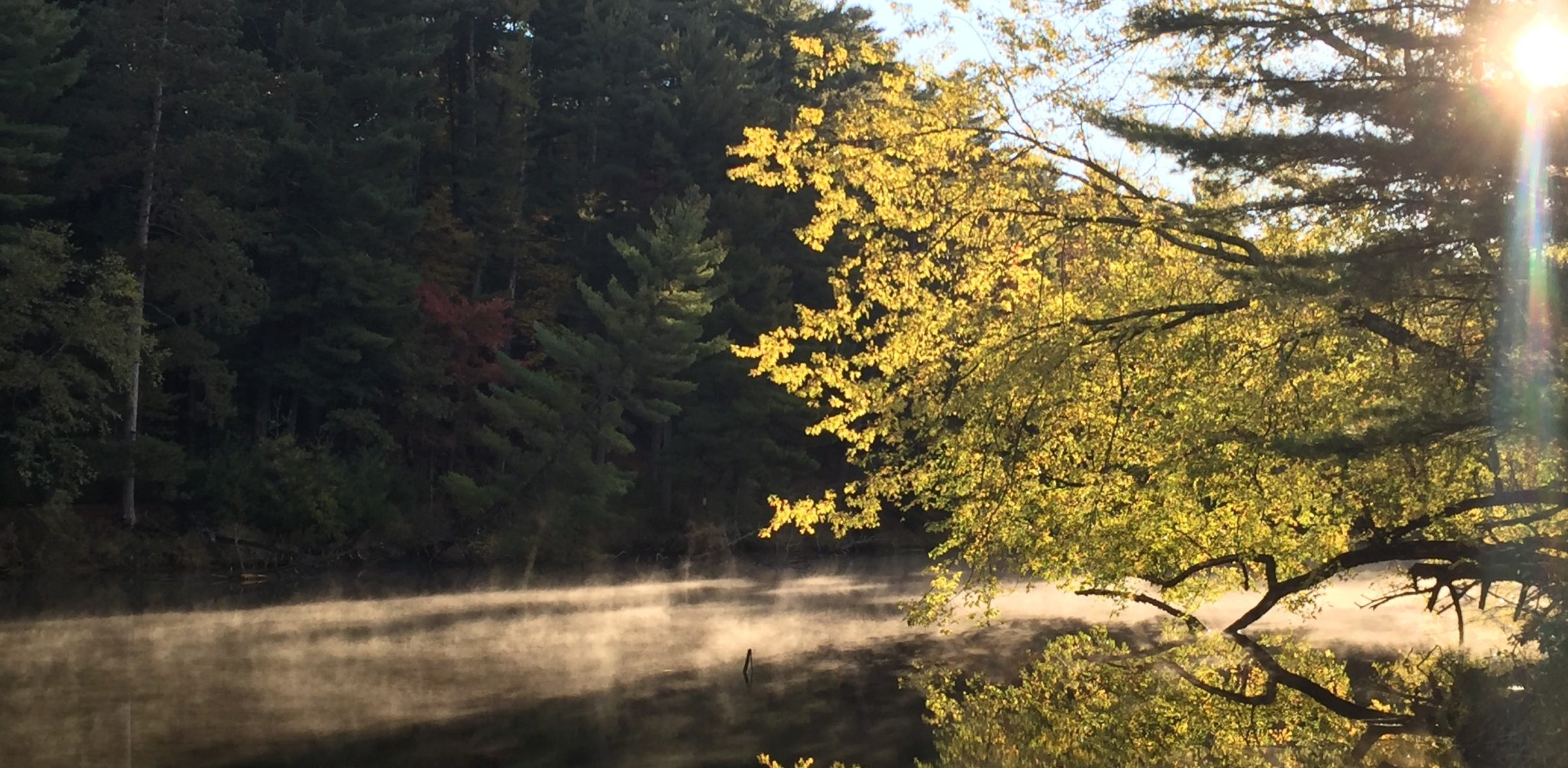
Upham Woods is located along the famous Dells (Dalles) of the Wisconsin River, 2 miles northwest of Wisconsin Dells, Wisconsin. Upham Woods consists of 318.7 acres of land on the banks of the Wisconsin River, including a 210-acre island called Blackhawk Island. The land is split into two parts by an old and now flooded glacial channel of the Wisconsin River, whose main channel, cutting a deep and narrow gorge in the soft Cambrian sandstones, forms the eastern border of the property. Between the old channel and the present-day Wisconsin River is Blackhawk Island, and on the west bank of the channel is a strip of land where the camp itself is located (dorms, cabins, lodge, nature center, staff duplex, and welcome center).
Named after Chief Blackhawk of the Sauk Native Americans, Blackhawk Island and the surrounding land was inhabited by the Ho-Chunk or the “people of the Big Voice.” Wisconsin was where they believed life was created and would be sustained. The tribe occupied this land, their Eden, for hundreds of years prior to French fur traders making contact in 1634. With the Europeans came diseases and warfare, resulting in a large tribal decrease from around 5,000 members to under 700. The Ho-Chunk slowly recovered, intermarrying with other tribes to boost their numbers.
It was during this time that white settlers began to flood the region, claiming the land as theirs to own. To ensure they would not have any competition, the United States government attempted multiple times to forcibly remove Ho-Chunk populations throughout the 1800s. The Ho-Chunk fought time and time again to stay on the sacred land, managing to maintain residence in Wisconsin but losing much of their territory along the way, including Blackhawk Island.
Almost all of the land was given as a gift to the University in 1941. Mrs. A.V. Keene and Mrs. C.H. Davis (Upham sisters) presented 310 acres of forested land as a memorial to their parents Horace J. and Mary Green Upham, for who the camp was named. The University then bought 8.7 acres in 1947 to add to this gift.
The Upham sisters wanted to maintain the woodland as they remembered it from their childhood. When the land was given, it was stipulated that no part of the land can be sold, used commercially, or made into a public park. Blackhawk Island itself must remain in its natural state and no permanent structures can be built on it. It, therefore, represents a valuable Scientific Area and State Natural Area for teaching, research, and aesthetic enjoyment.
The provisions state, “The lands shall be used as an outdoor laboratory and camp for youth such as 4-H clubs, and other people cooperation with the University of Wisconsin in the advancement of conservation, of agriculture, and rural culture”.
Click here to explore the history of Upham:
[wooslider slide_page=”timeline” slider_type=”slides” limit=”11″ thumbnails=”default” id=”timeline” order=”ASC” order_by=”date”]
Geology of Blackhawk Island
The Dells of the Wisconsin River are located at the southern margin of the Central Sand Plains of Wisconsin. These plains are underlain by sand deposition in a large glacial lake. The Dells are characterized by nearly vertical rock cliffs along the river, which are flanked by flat to gently rolling backlands.
The sandstone exposed in the cliffs was formed about 510-520 million years ago during the Cambrian Period. The sandstone in the cliffs were deposited as windblown dune sands, which are characterized by conspicuously inclined layering seen in many places. During their depositions, the seashore lay to the west between the Dells and the Mississippi River. The sea gradually encroached eastward to flood the Dells area, and as this happened, the region was temporarily part of the sandy shore of a seas in which the sandstone above the gorges was deposited.
There is a long gap in the recorded geology following the Early Ordovician. No deposits are known for the interval between 500 million years and the last glaciation of Wisconsin (20,000 years ago). The great continental glacier, the Laurentide Ice Sheet, flowed southward through the Green Bay lowland, over the east end of the Baraboo Hills, and to within 3 miles of the upper Dells. Approximately 15,000 years ago, the ice front dammed the Wisconsin River at a point one mile east of of present Lake Delton to form Glacial Lake Wisconsin, which was about as large as Utah’s Great Salt Lake and as much as 150 feet deep.
This lake drowned the Dells area and stretched north across the Central Sand Plains nearly to Wisconsin Rapids. As the glacier began melting about 14,000 years ago, the ice dam failed and the lake drained rapidly southward. Flow from the lake was constricted by sandstone ridges to the west and a moraine southeast of the Dells. As the huge volume of water rushed southward through a gap less than a mile wide, it carved the network of narrow, steep-sided canyons visible today. Within a few days, Glacial Lake Wisconsin’s water level dropped as much as 100 feet. The great flood carved the main Wisconsin Dells corridor, tributary canyons on the east side, and the canyons cutting west of Blackhawk Island and through Rocky Arbor State Park on the west side. It also stripped away the glacial lake deposits from the uplands surrounding these canyons.
References:
O’Malley, Dave, et al. “Dells of the Wisconsin River State Natural Area Master Plan and Environmental Assessment.” Dells of the Wisconsin River State Natural Area Master Plan and Environmental Assessment, Wisconsin Dept. of Natural Resources, 1997, pp. 1–53.
Hydrology of the Wisconsin River
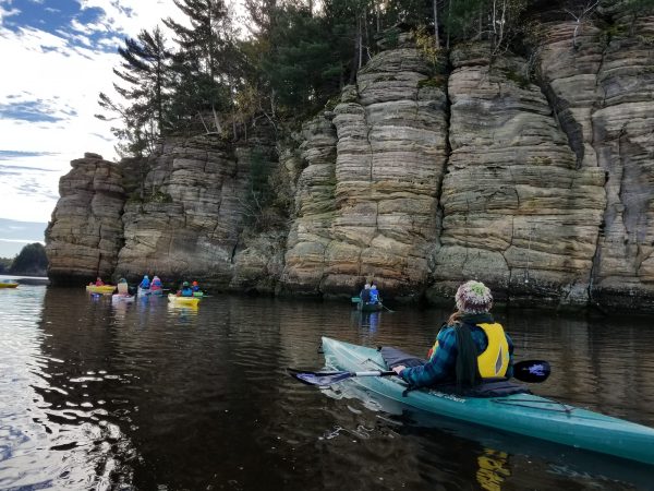
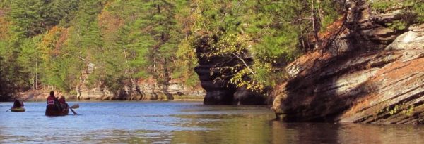
The Wisconsin River in both the Upper and Lower Dells is characterized by a sandy bottom with areas of rock ledges. Flow in the river is highly variable and is heavily influenced by the operation of the Castle Rock dam approximately 14 miles upriver from the Upper Dells and the Kilbourn Dam located within the City of Wisconsin Dells. The Kilbourn Dam is the dividing line between the Upper and Lower Dells. Blackhawk Island is located in the Upper Dells. The Kilbourn dam was completed in 1909 to improve navigation and to create hydroelectric power. It is currently owned by Wisconsin Power and Light. The water level in the Upper Dells was raised as much as 16 feet above existing levels. This filled the old channel making Blackhawk Island an island. Both of these dams are operated on a peaking basis.
The river itself is known for its strong swirling currents, which at times of higher water levels can make navigation difficult particularly in the narrows near Devil’s Elbow of Blackhawk Island (most eastern point of the island). Sandbars along the river corridor are the result of deposition of sands by the current. These sandbars change shape and size periodically due to action by the river. During periods of high water, these sandbars are completely submerged. The maximum depth of the river in the Upper Dells is approximately 100 feet and is also the narrowest part of the river at 52 feet in width. This area is located at Devil’s Elbow. Further upstream, near Stand Rock and north of Witches Gultch, the river widens and is shallow and flowage-like for a distance of approximately 4 miles.
Upham Woods is located in the Lower Wisconsin River Basin which drains approximately 4,940 miles of south central and southwestern Wisconsin. Upham Woods is located in the Dell Creek Watershed. Agriculture is the predominant land-use in this watershed. It has also been named a priority watershed and is currently being evaluated to assess impacts to water quality and determine methods to lessen these impacts. Water quality in this portion of the Wisconsin River is generally good.
References:
O’Malley, Dave, et al. “Dells of the Wisconsin River State Natural Area Master Plan and Environmental Assessment.” Dells of the Wisconsin River State Natural Area Master Plan and Environmental Assessment, Wisconsin Dept. of Natural Resources, 1997, pp. 1–53.
Soils of Blackhawk Island
The top of the island is fairly level except for two knolls each approximately 3 meters higher than the surrounding land. On the north and east sides, the underlying Upper Cambrian sandstone crops out in cliffs. Depth through the soil to the underlying sandstone is approximately 1 meter across the top of the island except on the two knolls where the soil is thinner. There are two river terraces on the west end of the island, one higher and older than the other. Both are composed of sandy alluvium. The material across the top of the island, and within which the soils have developed, grades from loams and sandy clay-loams on the west, north, and south to the silty clay-loams slightly to the east of center of the island. Silt loams cane be found on the northern and eastern edge of the island at the break in slope before the sand stone cliffs. Sometimes a thin, 4-10 cm, layer of sand and sandstone cobbles is sandwiched between soil profile and the bedrock; more often, the soil lies directly on top of the bedrock. The boundary between the soil and the sandy layer or bedrock is sharp throughout the top of the island and no sandstone cobbles or psuedomorphs are found in the profiles (Pastor, et al., 1982).
![]()
The soil of the youngest and lowest terrace, located below the cliffs near the western side of Blackhawk Island, is a Typic Udipsamment (Entisol). Buried forest floor in the profile attest to the flooding and deposition by the river. The soil of the older terrace, located above the cliffs, is an Entic Haplorthod (Spodosol), a soil rare in southern Wisconsin but common in northern Wisconsin. Soils across the top of the island, expect for soils on the sandstone knolls, are all Typic Hapludalfs (Alfisols), the most common of the region. The soil on the larger of the two knolls is Typoic Dystrochrept (Inceptisols), a soil midway in development between the sandy Entisol of the youngest terrace and the remaining Alfisols. Soils not on the main transect (see figure below) include Folists (Histosols) on cliffs and plowed Alfisols near the center of the island. The soil on the smaller of the two knolls in also a Folist. The silt and clay content of the soil increases steadily across the island from west to east following the main transect (Pastor, et al., 1982).
References:
Pastor, John, et al. “Geology, Soils and Vegetation of Blackhawk Island, Wisconsin.” American Midland Naturalist, vol. 108, no. 2, 1982, p. 266., doi:10.2307/2425487.
Above figure from Pastor, et al., 1982
Vegetation of Upham Woods
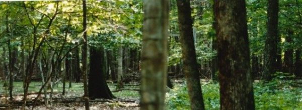
According to the 1851 Federal Land Survey, the vegetation vicinity of Upham Woods included oak savanna on the flat, sandy upland plains, and mixed forests of maple, oak, birch, cedar, and pines on the slopes of the ridges and the steep banks of the Wisconsin River. Most of these elements, excluding oak savanna, are still found on site today. The current vegetation of Upham Woods is a combination of relatively undisturbed natural plant communities. The natural vegetation contains elements from both southern and northern Wisconsin communities. This combination in a small area makes the site unique and ideal for research and teaching (Aber, et al. 1985).
The North Shore is dominated by forests of white oak and white pine. Blackhawk Island is also generally wooded with a mosaic of different community types including areas dominated by 1) red oak, white pine, and white oak 2) red and white pine with some red oaks 3) red oak, white oak, sugar maple, and basswood 4) hemlock with some yellow birch and white cedar 5) white oak, white pine, and red maple 6) river birch, cottonwood and red maple. Big tooth aspen is dominant in two small areas which were once logged and plowed for field crops (Aber, et al. 1985).
The mainland is dominated by a varying mix of white and red oak and red and white pine. The plantings around the buildings include various species and do not necessarily relate to one another or to the natural vegetation of the site.
Skunk Cabbage Gulch, Rockfall Gorge, and Spring Gulch contain some of the most interesting vegetation on the site. Upham Woods is one of the best places in Wisconsin to study ferns as nearly 1/3 of the state’s known taxa can be found (Aber, et al. 1985).
Putty root is found in rich woods, north- and east-facing slopes, and in low, flat areas. Blooming occurs May through June; fruiting occurs June through September.
During another survey of Blackhawk Island also in 1996, several distinctly different habitats were identified (Iltis et al, 1996). These include:
- Prairies: on sandbars and old river channel banks, as well as behind the cabins on the mainland, and on small prairie patches on the rim of the sandstone bluffs overlooking the river. Most of the species here have western affinities
- Pine Woods: of white, red, and jack pines, growing on about three sides of the island, as well as behind the cabins where jack pines are succeeding weeds and prairie fauna.
- Maple Woods: on top and in the center of the island, very rich in species of mesophytic herbs, these mainly with southern affinities.
- Hemlock Woods: mainly on rocky sandstone cliffs and slopes overlooking the Narrows of the Wisconsin River. On the north and east sides of Blackhawk Island.
- Sandstone Cliffs: on the northern and east sides of the island. These cliffs are particularly interesting. Where wooded, they are cool and moist offering habitat for many ferns and boreal species. On the level of the cliffs, on the every margin, are a number of typical bog species such as Gaylussacia baccata, the huckleberry, and Ledum groenlandicum, Labrador tea, which are able to grow there, high and dry due to the pronounced acidity of the sandstone.
A full plant species list of Blackhawk Island from this survey is available upon request. We also have an iNaturalist project filled with species identified by visitors.
[wooslider slide_page=”vegetation” slider_type=”slides” limit=”14″ thumbnails=”default” order=”DESC” order_by=”date”]
Various succession has been occurring as well as the introduction of invasive species. On the mainland, most of the understory is characterized by prickly ash, buckthorn, Rubus sp., and honey suckle. Other invasives that are present include garlic mustard, crown-vetch, and bird’s foot trefoil. Steps are being made to control these species.
On Blackhawk Island, invasive species have made relatively little impact. The largest impact on the island has been made by Japanese barberry. There have been only two buckthorn saplings discovered on the island and were promptly removed. Garlic mustard has also been found on the island, but in very small populations (less than 10 plants). These populations are currently being monitored and removed.
References:
Aber, John, et al. Upham Woods Master Plan 1985. University of Wisconsin-Extension, 1985, pp. 1–35, Upham Woods Master Plan 1985.
Iltis, Hugh H, et al. A Preliminary Checklist of the Ferns and Seed Plants of Upham Woods, Blackhawk Island, Juneau County, Wisconsin. Edited by Ronald Liesner et al., Herbarium of the University of Wisconsin – Madison, 1996.
O’Malley, Dave, et al. “Dells of the Wisconsin River State Natural Area Master Plan and Environmental Assessment.” Dells of the Wisconsin River State Natural Area Master Plan and Environmental Assessment, Wisconsin Dept. of Natural Resources, 1997, pp. 1–53.
Upham Woods Deer Exclosures
Two deer exclosures were constructed on Blackhawk Island in 1988. The exclosures are located on the east side of Overland Trail near the intersection of Overland and White Tail Trails and off of Narrows Trail approximately half-way between Devil’s Elbow and Upham Cave. These exclosures were randomly sampled for several years to catalog and compare the exclosure and the surrounding area.
There is a distinct and obvious difference between inside the exclosures and outside. According to Upham Woods archives, during the late 80’s and early 90’s deer browse was at its worse. There was virtually no regeneration other than maple saplings to succeed the yellow birch, oak, pine, and hemlock outside of the exclosures, which the island has been so well known for. Inside both exclosures during this time period, there was a near complete ground cover of grass, forbs, and woody seedlings compared to the scattered forbs and virtually no woody seedlings on the outside. Today, the exclosures still show a marked difference between browsed and not-browsed vegetation, however, not as extreme as the 1980’s and 1990’s. Deer management practices have helped limit deer browse. In the exclosures today, you can expect to find putty root (Aplectrum hyemale), bellwort (Actaea spicata), bloodroot (Sanguinaria canadensis), American ginseng (Panax quinquefolius), ramp (Allium tricoccum), maidenhair fern (Adiantum), Jack-in-the Pulpit (Arisaema triphyllum), and much more.
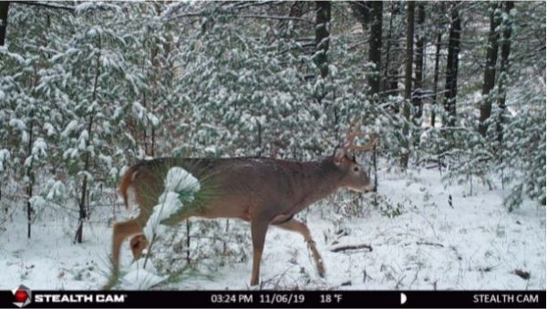
A buck was spotted on our trailcam by our Blackhawk Island campsite.
Upham is currently using trail cameras to conduct an observational study to track relative deer abundance. This will allow land managers to assess the change in herd populations and approximate the sex ratio. Observational data is recorded via trail cameras. In order to compare years, data must be collected in the same manner during the same time period each year. The fall season dates of observation on Blackhawk Island are 10/14-12/2. A spring time monitoring will also take place to determine doe to fawn ratios and fawn recruitment rates. A date for the spring observations have not been determined yet, as it will rely on river conditions and access to Blackhawk Island.
From just this preliminary data, we are unable to fully estimate the deer population. However, we are able to start our comparative study of relative abundance. From the rate of deer observations per hour, we can compare the changing abundance through the years and estimate the effectiveness of current deer management and deer population size on Blackhawk Island. For more information on this monitoring effort check out Upham’s Deer Monitoring Report 2019
Fire History:
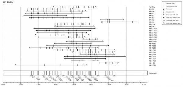
According to Upham Woods Archives, a crew of DNR employees, led by Jed Meunier, sampled three locations – two spots in the Dells of the Wisconsin River State Natural Area (WD67, WD1), one in Rocky Arbor State Park (RA) as well as a couple samples, one which was dated, from Mirror Lake State Park (ML). The graph below is a representation of the samples where each horizontal line is a sample, usually a cross section from a stump via a tree cut around European-settlement but occasionally later (subsequent harvests). The dates at the bottom represent fires on > 2 samples. There were obviously frequent fires. 225 unique fire years from 1634 – 2018, and a Mean Fire Return Interval of 4.74 years for fires on > 2 samples. Many of these fire years were synchronous across large regions of Wisconsin (and also Michigan). The DNR has data for over 60 stands throughout Wisconsin including several sites in the Central Sands Ecological Landscape (Quincy Bluff, Fort McCoy, Levis Mound, Bruce Mound, Wildcat Ridge, Stony Bluff) and Baraboo Hills.
Blackhawk Island has had fire suppressed similar to the rest of the region since at least 1941 when the University of Wisconsin acquired the land. There was a fire that swept over Blackhawk Island in April of 1980 that, according the Lyndon Station Fire Department, was started by sparks from a Milwaukee Road freight train. The fire itself burned approximately 1,500-2,000 acres of wooded land. Several maple trees on Blackhawk Island show burn scars from this fire. According to neighbors’ accounts, the last fire before this was in 1912. No other records remain from the 1912 fire.